Topography
1- Coordinated geographic
2- System of show of the earth
3- The North
4- A map
5- Orientation
6- The GPS
1- Coordinated geographic
|
To be able to track down every point of the earth, this one has undergo an axial division giving meridians and
a transverse division giving parallels.
So any place can be tracked down in the means of two coordinated which are longitude
and the latitude. |
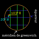
The point S has for longitude the value of the angle A and for latitude the value of the angle B.
From 1985 for the French system, the meridian zero corresponds to the one that passes by Paris,
after the desolation of the meridian of Greenwich (England). Parallel zero is the equator.
The marketing research of points in the space and time
in the neighborhood of the earth require the definition of a geodesic system
of reference. The geodesic coordinates of a point are relative to a construction
theoretical. A reference ellipsoďde (sphere flattened in poles) and a point are used
fundamental (chosen). French system NTF (New Triangulation
of France) uses the ellipsoďde Clarke 1880 IGN, European system ED50
(Europe Datum on 1950) uses the ellipsoďde Hayford 1909, and American system (used all over the world)
WGS84 (World Geodetic System on 1984) uses the ellipsoďde
IAG GRS1980. |
|
So for placed points east of Paris, longitude is counted in degrees is, on the West of Paris in degrees
the West; for points placed in the North of the equator, latitude is counted in degrees the North, in the South of the equator
in degrees the South. Longitudes are mostly counted positively eastward, with regard to
meridian of origin. For systems, others than French system, the meridian of origin
is the meridian of Greenwich.
"Réseau Géodésique Français" RGF is
new reference system (geodesic system, on 2002), tridimensionnel,
geocentrique and of exactness centimetrique. It replaces the NTF today.
The RGF is organized into a hierarchy in 3 networks :
- a reference network, the RRF (23 points)
- a basic network, the RBF (1000 points)
- a network of detail in the course of definition.
System so defined is called RGF93.
Ellipsoďde : GRS80. It is on this ellipsoďde that are expressed
the geographic coordinates (longitude, latitude and height) of the RGF93 system.
Latitudes and longitudes RGF93 are expressed in sexagesimal degrees,
the origin of longitudes is meridien of Greenwich, the associated ellipsoďde
is IAG GRS80, unity shelf space is the metre.
top
2- System of show of the earth
To pass of a spherical show in a flat show (cards, plans) more practical to consult
in raid, several methods are possible :
- keep the values of angles. It is Lambert's corresponding projection that is used in France by the IGN.
- keep the relative value of surfaces. Used for the creation of the cadastre.
a- Projection Lambert
|
It presses on a covering by squares, which introduces only a maximal error of 36 cms by km.
France is cut in four zones Lambert:
- zone Lambert I (the North of France)
- zone Lambert II (centre of France)
- zone Lambert III (the South of France)
- zone Lambert IV (the Corse)
1 grade (rank): angle equal to the hundredth part of a right angle (100gr=90°)
|
Projection Lambert = conical projection : the surface of projection is
a cone tangent or secant. |
|
b- Projection Universal Transverse Mercator (U.T.M)
This projection is used in the other countries, and is based
on an average meridian and not on an average parallel. UTM system is on the other hand applicable
everywhere. Meridian sound zero corresponds to the meridian of Greenwich.
The earth is cut in 60 reels of 6 ° each (longitude), and 20 bands of 8 °
(latitude), that give 600 zones UTM.
 |
UTM North reel 30: between 6 degrees the West and 0 degrees Greenwich
UTM North reel 31: between 0 degrees and 6 degrees is Greenwich
UTM North reel 32: between 6 degrees is and 12 degrees is Greenwich |
|
|
|
Projection UTM = cylindrical projection: the surface
of projection is
a cylinder tangent or secant. |
top
3- The North
a- The geographic North
 |
Meridians and parallels are registered on cards
and establish geographic pattern. The pattern is registered every
décigrades on cards IGN in 1:25000 and 1:50000. The left coasts and right of these card are
meridians and indicate the geographic North. |
b- The magnetic North
The magnetic North represents the point of the earth
towards that is attracted the needle of the compass. It is in 1900 km of the North Pole,
in the Canadian archipelago Artique. One calls up magnetic declension,
the angle between the magnetic and geographic North. This one is given on every card,
fields magnetic earthly being variable. |
|
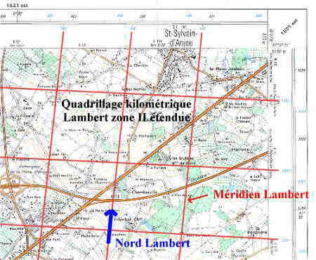
c- The North Lambert
The North Lambert is given by meridians Lambert.
Map IGN 1/25000 :
- scale inside = longitude and latitude
in rank (scale in hundredth of ranks)
(meridian of Paris), reported to the French geodesic system NTF. Onsets
black are those of the kilometric covering Lambert zone X (Lambert I, II, III or IV).
In blue, the onsets of the kilometric covering vast Lambert II.
- scale outside = longitude and latitude
in degree (scale in minutes) (international meridian of Greenwich),
reported to the unified European geodesic system ED50.
Onsets are those of the kilometric covering
Universal Mercator Transverse (UTM) reel Y.
In black, the onsets of the covering UTM of the reel corresponding to the zone; in limit of two reels,
onsets coexist in blue and black, the weakest values corresponding to the reel of number
superior.
|
New card IGN 1/25000 GPS compatible (since 03/99):
1 = coordinated kilometric Lambert zones II vast,
reported to the NTF geodesic system
2 = coordinated kilometric UTM, reported to the WGS84
geodesic system
(World Geodetic System 1984 - USA)
-> for GPS
3 = latitude in rank, reported to the NTF geodesic system
4 = latitude in degree, reported to the ED50 geodesic system |
2002 : New map 1/25000
TOP25 and Série bleue in revision :
The two scales of latitudes and longitudes of the frame and chiffraisons
kilometric correspond respectively :
- inward, in latitudes and longitudes in ranks (longitudes
referred to the meridian of Paris) reported to the French geodesic system NTF;
onsets are those of kilometric coverings Lambert zones III
(coded in black) and Lambert zones II spread (coded in blue);
- towards the outside, in latitudes and longitudes in degrees (longitudes
referred to the international meridian) reported to the world geodesic system
WGS84 ou RGF93 ; the blue chiffraisons in italic compared to the covering
kilometric is coordinate Mercator Transverse Universal (UTM) reel 31 or 32.
ED50 disappears of these maps.
Série bleue in reprinting :
It constitutes the majority of cards. Covering GPS is stuck on
the existing frame and ED50 subsiste. The text of existing legends is
not modified. It comes only to add a sentence has the suite of the legend
current :
"The blue chiffraisons in italic compared to the kilometric covering
is coordinate Mercator Transverse Universal reel 31 or 32 reported
in the world geodesic system WGS84 or RGF93."
The earthly maps (included reliefs) are drawn up with it
support of a geodesic network makes of triangles of which each has a common side
with one of his neighbours (geodesic system). Every geodesic point is known by its coordinates and
the height (80000 points).
top
4- A map
a- Scale
The scale = outstrips AB on the card / outstrip AB on the ground
1/25000 gives for 1 cm on the card, 25000 cms (250 m) on the ground (4 cm = 1 km).
b- Contour lines
The équi-distance enters them curve of levels corresponds
unlike level between two nearby curves (given in the legend).
c- Angles
They confront clockwise.
|
We are there A, and we want to go B there.
The angle X corresponds to a magnetic azimuth here.
The angle Y corresponds to a geographic azimuth here.
The deposit is the angle that makes direction AB with the North Lambert. |
d- Hillsides
A hillside of 4 % means that level rises (for an ascent) of 4 m
for 100 m of horizontal distance.
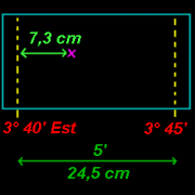
e- Location of a place
Calculate longitude and the latitude of a point on a map in 1/25000 :
|
Calculate longitude :
The point is 7,3 cms of the longitude 3°40' and between longitudes
3°40' and 3°45' there is 5' of distance and 24,5 cms.
24,5 cm give 5' et 7,3 cm give x ;
so x = (7,3 x 5)/24,5
x = 1,4897' = 1,49' ; x = 1' et 0,49' = 1' et (0,49 x 60)''
x = 1' 29,4'' = 1' 29'' (0,4 x 60)''' = 1' 29'' 24'''
Longitude is : 3° 40' + 1' 29'' 24''' = 3° 41' 29'' 24'''
Process is the same for the latitude with the vertical axis. |
Position a point on a map 1/25000 knowing its longitude and its latitude :
The point to localize on the card has for longitude 3°41' 29". The point is so
in 1'29" (to the right) of the axis representing a longitude of 3°40'.
Between longitudes 3°40' and 3°45' there is 5' of distance and 24,5 cms.
5' give 24,5 cm et 1'29'' give y ; let us transform quite in seconds, 5' = 5 x 60 = 300''
and 1'29'' = 60'' + 29'' = 89'' ;
so y = (89 x 24,5)/300 = 7,268 = 7,3 cm
The point is 7,3 cms of the axis representing a longitude of 3°40'.
Process is the same for the latitude with the vertical axis.
f- Go with the compass

The geographic North NG is given by edges the West and is of the card.
X = magnetic declension. |
We are there A, and we want to go B there.
Measure on the card of the geographic azimuth = 210°
Calculation of the magnetic azimuth (direction to be used with the compass) =
210° + X |

Direction to set corresponds to the yellow arrow. |
top
5- Orientation
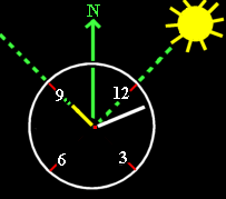
a- With a watch
|
|
North moderate zone |
South moderate zone |
The hour of the watch must be at the hour
universal, that of the sun (in France winter, to delay of one hour the watch).
b- Without watch
|
Take a stick, plant it, mark the end of
shadow by a stone P1, to wait for 15 minutes, then to mark shadow
by a stone P2. Draw a crossing right-hand side by points P1 and P2, then everything
the rest (to see drawing). Put the stick in A to have hour. |
Sun: gets up in the East (little in the South of is it) and gone to bed on the West
(little in the North of the West).
Local noon: indicated by the briefest shadow.
c- Moon phases
At midnight, the moon indicates the South when it is full, the West in the first district,
is it in the last district.
|
The East |
The South |
The West |
The North |
The new Moon |
6 h |
12 h |
18 h |
24 h |
First district |
12 h |
18 h |
24 h |
6 h |
Full moon |
18 h |
24 h |
6 h |
12 h |
Last district |
24 h |
6 h |
12 h |
18 h |
|
|
First district |
Last district |
d- With stars
Hemisphere the North
|
Hemisphere the South
|
|
|
Find the great she-bear and
follow the continuation of Y. |
The arc of a circle in dotted line corresponds to the
direction
of the movement on the heavenly sphere. |
At midday solar energy, the sun indicates the South (the summer, the sun are high in the sky).
e- Place of the sun
|
In June 21, sun in 23,4 ° N soltice summer
In March 20 and September 23, autumn or spring equinox, sun in 0 ° in the equator
In December 21, sun in 23,4 ° soltice of winter
|
f- Determination of point
Longitude = difference between the beginning of local noon and the hour of Greenwich (watch).
|
example : 6 h 52 mn
one obtains: (6 x 15 °) + (52 x 0,25 °) = 103 ° of longitude is or the West (to know) |
Latitude = in the north hemisphere, measures height in degree of the pole star
above the horizon.
Other method with the exact duration of day.
top
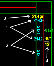
6- The GPS
On a card IGN, two scales(ladders) appear in the carrying frame of
chiffraisons kilometric (to see image of card IGN higher):
- inward = in black, the onsets of the kilometric covering Lambert
zone I, II , III, or IV. Kilometric chiffraisons indicates the zone Lambert,
for example 3196 = 196000 m Lambert III. In blue, the onsets of the covering
kilometric vast Lambert II. In grades, latitudes and longitudes by
report in the French system NTF
(NTF = geodesic system French).
- towards the outside = in black, the onsets of the covering UTM of the reel
corresponding in the zone (in limit of 2 reels, onsets coexist there
blue and in black, the smallest values corresponding to the reel
of upper number). In degrees, latitudes and longitudes by report
in the systemED50 (ED50 = unified geodesic system (european)).
A GPS indicates us coordinates in the system WGS84, System of which
show does not appear on cards all the time. Only
cards blue series and Top 25 republished (IGN) or published since the first
in March, 1999 include a covering UTM / WGS84, allowing a correspondence
between the card and the GPS.
Here are some explanations for the conversion NTF towards WGS84 and vice versa
for the old cards :
From one card, calculation of a GPS (NTF towards WGS84) :
Example with a card in 1/100 000 (preciseness of 100m) :
- raise coordinates in grades from onsets (sign
positive or negative according to the position with regard to the meridian of Paris)
- transform them into decimal knowing degrees that 400 grades = 360 °
and that 1 grade = 0,9 °
- transform them into sexagesimal degrees (degrees, minutes, seconds)
for example, 3,5721° decimal = 3 degrees + (0,5721 x 60) minutes =
3° + 34,326 ' = 3° + 34' + (0,326 x 60) seconds = 3° 34' 19,56''
- for a longitude, conversation for the passage of the meridian of Paris
in the meridian of Greenwich by adding 2° 20' 14,025''
(3° 34' 19,56'' + 2° 20' 14,025'' = 5° 54' 33,585'')
Example of Redon : longitude NTF = -4,907 grades (4,907 gr WEST = -4,907 gr) and latitude NTF = 52,948 grades
gives longitude WGS84 = - 2° 04' 44,655'' and latitude WGS84 = 47° 39' 11,520''
Transfer of coordinates GPS on a card (WGS84 towards NTF) :
You can read on your GPS four types of coordinates (following
the complexity of the GPS) :
- In the ED50 system
in degrees, minutes, seconds. To put back on the card
by basing itself with regard to coordinates in italic in sexagesimal degrees (on it
margin of the card).
- in the ED50 system in flat coordinates kilometric UTM (to clarify
the reel on the GPS). To put back
on the card by basing itself with regard to the kilometric coordinates in black
and in italic outside of the margin (example: 5247 , 677) (only onsets
of the covering allow to read coordinates on the card).
- in the NTF system in ranks. To put back on the card
by basing itself with regard to coordinates in ranks appearing inside
of the frame in black (lines in the card represent meridians
and parallels, example 52,60 gr). Parameters to return on the GPS
for the NTF system: Tx =-168m, Ty 60m , Tz=320m, parameters ellipsoîde
(Clarke on 1880 IGN) half main line = 6378249,2m, half small axis =
1 / f=293,466021, gap longitude Greenwich / Paris = 2° 20' 14,025''
- in the NTF system in kilometric coordinates Lambert. To put back on the card
by basing itself with regard to the kilometric coordinates present in
the inside of the in black frame or blue in the projection zones Lambert
(example: 2265 , 373).
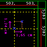
Put back kilometric coordinates UTM/ED50 GPS on a map IGN 1/25000 :
Reading of the GPS configured there UTM/ED50 : 30T 0502414 5282310
|
- 30T indicates the corresponding zone UTM,
France being cut in 6 zones UTM |
|
- To draw on the card, a covering with the kilometric coordinates UTM/ED50
(outside scale)
- One has 0502414 5282310,
track down the point of coordinates 502,5282
- 414 implies a gap towards the right-hand side of 414 metres,
now on the card 1 km = 4 cms,
so 414 m = 0,414 km corresponds to 0,414 x 4 cms = 1,65 cms
- 310 implies a gap upward 310 metres, now on the card 1 km = 4 cms,
so 310 m = 0,310 km corresponds to 0,310 x 4 cms = 1,24 cms
- You obtain so the wished point
|
top